Thursday, April 17, 2014

Population Profile

http://www.ifad.org/operations/regional/pf/aids_1.htm
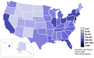
Population profiles are used to show fluctuations in population as it correlates with age. In the graph above it shows the population density of people with and without aids at certain ages. The largest number of people without aids for both men and women was 0 years of age. The largest number of people with aids for both men and women was at 20 years of age. These profiles allow us to see how age affects the amount of population given certain circumstances. 

Lorenz Curve

http://en.wikipedia.org/wiki/Lorenz_curve

The Lorenz Curve is often used in economics. It shows the likelihood of distribution between two variables. The gray area represents the "area of inequality". 

Correlation Matrix

http://www.thelancet.com/journals/lancet/article/PIIS0140673698071645/table?tableid=tbl4&tableidtype=table_id&sectionType=red

Correlation Matrix's are used to show the correlation and direct relationship between two variables. By putting a variable on each axis you can see the downward slope and correlation.

Parallel Coordinate Graph

http://en.wikipedia.org/wiki/Parallel_coordinates

Parallel coordinate plot is used to show multiple variables data. As shown above, they can sometimes get jumbled up and hard to read because of all the data; therefore, the graphs are used more for showing a high density in numbers rather than specifics. 

Windrose


Windrose's are used to show the distribution of windspeed in a given area. According to this graph, the northwest would be receiving the highest wind speeds. This is shown by using the lime green color.

Index Value Plot

https://blogger.googleusercontent.com/img/b/R29vZ2xl/AVvXsEhcA3POLio_5xxGlGw3bsZf-VPGy4t_Ef2K1XQDFFfBHIeiA1XqltvMCrCgRlBm9rJAp9lsB4B2uSOkr_96b6rdfgibXBh2H9IZOYEnkLO92uUomIEqYNTRQ66VjPYGhjafjT1ERzIPNds/s1600/index+value+plot.png
Index value plot is used to plot data without the data being precise and exact. Its more of a range of data that is used and then plotted accordingly. The type of graph used is a line graph. 

Stem and Leaf Plot

http://mainland.cctt.org/mathsummer/josephbond/stemandplots/stem-and-leaf_std.htm
Stem and Leaf plot show the amount or frequency for different values of data. For example, the graph above shows that the three hundreds had the biggest range of data. The stem is the first number and the leaf is the second half. You combine the two for the final number. If the stem is 3 and the leaf is 10 it is 310. 

Box Plot

http://en.wikipedia.org/wiki/Box_plot
Box plots are used to show a range of data. They are also used to show the central value in each of the quartiles.

Histogram

A histogram looks very similar to a bar graph. The difference is that histograms are used to show frequency. For example, in the graph above the height of Black Cherry Trees between 60-65 ft had a frequency of 3. The data is portrayed like a bar graph but the data is a little different.

Climograph

Climographs chart monthly precipitation and temperature for a certain location. Above shows a basic climograph. From this map it can be understood that July is the warmest and wettest month.

Scatter Plot

Scatter plots are made with two different sets of data. It shows the relationship between both the x and y variable. For the graph above it shows that as the number of days increase so does the weight. The dots allow for a clear representation of a positive slope and direct correlation.

Bilateral Graph


Bilateral Graph compares at least two sets of data. For the graph above, it is comparing the percentage of exports and the percentage of imports. The data is portrayed as a bar graph which gives is easy to interpret.

Nominal Area Choropleth Map


Nominal area chorolpeth maps are based on location and area. For example, the graph above shows each states status on PLSS standardization. Green means completed, whereas white means its not considered a PLSS State.

Unstandardized Choropleth Map

http://davalt10.blogspot.com/2011/07/unstandardized-choropleth-map.html

Unstandardized choropleth maps are based on raw numbers. Most maps data are averaged out, but in these maps the numbers are left in their original form. 

Standardized Choropleth Map

http://emilyness16.blogspot.com/2012/03/standardized-choropleth-maps.html
Standardized choropleth mapping deals with population. The different shades of purple represent the population density per square mile in each state. 

Univariate Choropleth Map

Univariate choropleth maps are based on one set of data. This map shows presidential votes to each states electoral votes. That is the only data being portrayed in this map.

Bivariate Choropleth Map

Bivariate choropleth maps encompass two sets of data. For the map above it showing data for both median house value and county population. The color represents one variable and the shading represents another.

Unclassed Choropleth Map

Unclassed choropleth map has two extremes. 100 percent republican and 100 percent democrat. The shading in-between represents how extreme their beliefs are. For example, one who is undecided would be shaded as purple because they are in-between. This map shows the party distributions around the United States.

Classed Choropleth Map

This classed choropleth map uses colors to show the different ranges of males to females. Classed choropleth deals with specifics whereas unclassed is a broad range.

Range Graded Proportional Circle Map

http://go.owu.edu/~jbkrygie/krygier_html/geog_353/geog_353_lo/geog_353_lo11.html
The map shows course offerings in cartography by state. The size of the circles are proportional with the amount of offerings. The larger the amount of offerings, the bigger and darker the circle. 

Continuously Variable Proportional Circle Map

Continuously variable proportional circle map uses size  and color to depict one variable from another. This map also shows the high density in one area.

DOQQ


This is a DOQQ of Lake Travis. It shows an arial view and the breaks in land.

DEM


This is a digital elevation model of Lake Baikal. It shows the fluctuations in height throughout the lake.

DLG

DLG represents the digital line graphs of a certain area.

DRG

http://tahoe.usgs.gov/DRG.html
This is a DRG of Lake Tahoe Basin. It is based on the UTM NAD27 projections.

Isopleths

The isopleths are showing the fluctuations in latitudes between the different months.

Isopach

This isopach displays the thickness of an area using the lines.

Isohyets

http://pasca-mapcatalogexplore.blogspot.com/2011/04/isohyets.html
The lines are connecting areas that have had the same amount of precipitation yearly. Isohyets are used to tie together pieces that share the same data. Above, isohyets are used to show rainfall distribution in Hong Kong.

Isotachs

Isotachs are used to connect areas of equal wind speed. With the use of isotachs we can explore wind speed distribution and tendencies and find out which areas have similar climates as others.

Isobars

Isobars are used to connect areas of equal pressures. The lines show how air pressure fluctuates from area to area. By connecting places with the same data, it shows how other places compare.

LIDAR

This is a Lidar representation of a city in Utah. The different colors represent changes in elevation of buildings. Blue being the tallest and red being the shortest.

Doppler Radar

http://4warnwxteam.files.wordpress.com/2011/04/radar1.jpg
Doppler Radar is used to show precipitation amount, along with possible storm strength. It is how meteorologists explain possible weather forecasts and how civilians interpret it. 

Black and White Aerial Photo

This is an aerial photo of a city. It is in black and white so there is no color involved. Aerial view allows us to see everything from another perspective. We can see where things lie in relation to others that we couldn't see when were standing on land.

Infrared Aerial Photo

Infrared aerial photos allow us to see the "bigger" picture. What we can see from this photo we would not be able to see if we were standing on land. The infrared allows for layering and that can be broken down to find more information.

Cartographic Animation

These maps use animation to show previous or future weather possibilities. They can be very informative and are seemingly very popular because the majority of populations know how to properly interpret the information.

Statistical Map

This map is providing statistics in percent change in resident population for the 50 states, the District of Columbia, and Puerto Rico. It is statistical because they're are different places being compared to one another and because it is dealing with factual data.

Cartogram

This map is substituting colors for amount. The different colors represent the amphibian diversity in each country.

Flow Map

http://psjatechtrainer.pbworks.com/w/page/19592758/Thinking%20Maps
This type of map shows a process. It breaks down step by step. It gives detail of how one thing led to the next. This type of flow map represents a thought process. 

Isoline Map

The isoline map uses line to connect data that is the same. In this case, its temperatures around the Nation.

Proportional Circle Map

The size of the circle is proportional to the data. The larger the circle the bigger the farm size. In this case, Texas has the biggest farms.

Choropleth Map


http://www.geog.ucsb.edu/~jeff/gis/choropleth_maps.html
Choropleth maps use different shading of colors to represent different values. One can easily interpret these maps by looking at a color and then checking the scale to see what value it represents.

Dot Distribution Map

Dot distribution maps are used to represent population. The amount of dots is directly related to the population. Where there is heavy amount of dots it can be understood that there is a high volume of hispanic people. In this case, California has the most.

Propaganda Map

http://www.geocurrents.info/tag/propaganda#!prettyPhoto
Propaganda maps are used to tell a story. Usually they strive to tell a story or get a message across to its viewers. They can be influential. The map above is from Europe and expresses ones views on war.

Hypsometric Map

http://www.acsu.buffalo.edu/~dbertuca/maps/cat/map-portion-images.html

Hypsometric maps are a combination of contour lines and color. With both of those working together, it allows these maps to be very successful when displaying elevation and distance. The color makes it more user friendly and appealing to the eye. 

PLSS Map

http://nationalatlas.gov/articles/boundaries/a_plss.html
PLSS stands for Public Land Survey System. It helps to identify land. It is used throughout the Country completely as you can see that many states have no identified themselves as a PLSS state. It is extremely detailed and taken seriously. 

Cadastral Map


Cadastral Maps go into great detail. They show the ownership of land. With color they can show who owns what and how much they own compared to others. The whole map is based around the value and ownership of property.

Thematic Map


Thematic Maps are made based on a theme. This map uses color to show which parts of the United States use which soil moisture regimes. For example, Maine and some parts of California use UDIC. Bright and strong colors such as these make it easy to depict which states share the same usage and which states do not. Thematic maps that use color are extremely easy to extract data from. This map clearly states the affects that droughts have left across the nation.

Topographic Map


Topographic maps are known for the use of contour lines. The lines represent fluctuations in elevation. The smaller the circle the higher the elevation. This map shows the differences in mountain height. It is apparent that the terrain is not flat due to all the lines. Topographic maps would be extremely beneficial when planning a hiking trip. 


Planimetric Map


This is a planimetric map that is two dimensional. Planimetric maps shows horizontal positions without touching on the vertical positions. Many topographic features such as buildings are left out of the map. The purpose of this map is two show location rather than specific features. It gives a general eyeballing of how close things are to each other and where certain roads and major bodies of water are.

Mental Map


This is a mental map of the world. Andrew Shears is the creator of this map. A mental map is based on one's point of view and perception; therefore, it can be agreed that this is how he envisions the world. The map represents how Mr. Shears perceives the world.